


My name is John Van Leeuwen. I’m an independent consultant for 40 years in the agriculture sector. This is my story about why I adopted latest mapping and survey technology to help my business.
I specialize in irrigation services such as design for drip and micro systems, overhead cooling and frost mitigation systems for horticulture including orchards, vineyards, plant nurseries as well as landscape turf commercial irrigation design including sports fields and municipal gardens.
In the past I used to survey smaller properties or individual blocks with a measuring wheel and clinometer – a slow and not very accurate process requiring an assistant. In an era where cost pressures have increased and margins have become smaller, efficiency and accurate measurements have become very important. For example, oversized pumps use more power and uneven output of irrigation systems waste water and fertiliser can create irregular growth. Excessive pressure in irrigation submains can blow out grommets take-offs, lateral pipes can split or have emitters and connectors pop when the pressure rating is exceeded.
I tried a consumer-grade handheld bushwalking GPS in an effort to get quicker and more accurate survey information but soon realised that the data it produced was not accurate enough to be used for design at the standard required.
So, I approached CR Kennedy, a national and leading provider of survey solutions, and purchased a fully integrated mapping system. The solutions comprises the high-accuracy Leica Zeno GIS/GNSS Smart Antenna and Geolantis, which is a powerful cloud-based mapping and data management software. There is an intuitive Web-mapping portal and also a mobile application that I could install and run on my own smart phone. I found the system to be easy to use and be adaptable to my situation and requirements, which is mainly the setting up of the data layers and information I want to collect, including photos. Support from CR Kennedy has been excellent, as they took their time to help me learn this new tool. Very quickly I was able to do my first field job. Nowadays I rarely need to contact them, because it simply works.
The mapping system gives me centimetre accuracy in real-time both horizontally and vertically. This is critical for my design work. Substrate hydroponic systems, increasingly used to grow berries and other crops, operate for intervals of a minute or less. On terrains anything other than virtually flat it is vital that anti-drain valves are installed in lateral drip lines at specified elevation intervals. This is to prevent the lines from draining, as the media plants that are grown in have virtually no water holding capacity. It is imperative that when the irrigation system is turned on, all drippers start dripping immediately and stop the moment that a valve is turn off. To achieve such a design, centimetre accurate elevation data is required. The Leica Zeno GIS/GNSS Smart Antenna certainly provides this level of accuracy.
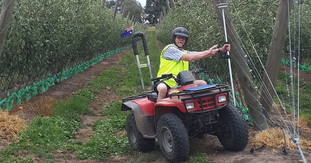
For larger projects I have found that when using an All-Terrain vehicle (ATV) like a quad bike I can accurately survey much larger properties than was previously possible. I recently surveyed a 30 Ha steep terrain vineyard in less than a day and a 200 Ha flower farm with irregular shaped blocks in one and a half days both with an ATV. Best of all, I no longer need a helper. I now carry out the work as a one-man operation, which offers significant cost savings.
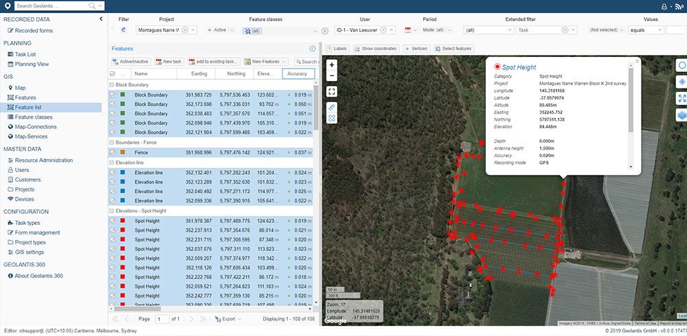
The survey data I collect in the field with the Leica Zeno GIS/GNSS system gets immediately uploaded to the cloud-based Geolantis.360 system. This means that as soon as I get back to my office I can view the final map and survey measurements, each of which has accurate easting, northing and height values that are referenced to the Geocentric Datum of Australia (GDA). Export of the data is easy. I use Irricad Hydraulic Design and CAD drawing software. Export of the data from the Geolantis system is easy and I can import and readily use the CAD survey files in my design software.
In summary, my investment in the Leica Zeno GIS/GNSS mapping system has allowed me to add another level of expertise and quality to my business and growers are appreciating this additional service. I have designed Irrigation systems in most states of Australia and look forward to continuing this work.
Author:
John Van Leeuwen, VAN LEEUWEN IRRIGATION SERVICES
Agricultural Drip / Micro & Landscape / Turf Certified Irrigation Designer
Phone: 03 9739 5085 & 0418 996 048
