

- Leica MS50 Multi Station
- Leica Viva GS15 GNSS receivers
- Leica GS10 base station with solar tracking
- Riegl Z and VZ model scanners
- Leica C10 laser scanners
- Leica TS15 Viva Robotic Total Station
- Leica TM30 and TM50 Monitoring Total Stations
- UAVER Avian fixed wing UAV
- Aibotix multicopter
Open Pit Survey
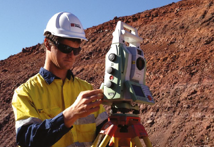
Frank Robinson is Downer Mining’s senior surveyor for a mining services contract in the Roy Hill Project in Western Australia’s Pilbara. Downer’s surveyors are currently using a Leica MS50 Multi Station and Leica Viva GS15 GNSS receivers for most of their work related to mine infrastructure and for the site clearing, topography, pit layout and drill pattern surveys. On a hill nearby, Downer also has a Leica GS10 base station with solar tracking.
Asked whether he thought Downer was working smarter since the boom, Robinson said: “That’s for sure. The mine’s preliminary work is quite diverse, and we need gear that gives us flexibility, so that’s the main reason we chose the MS50,” he said.
“It gives us 3D scanning, total station capability, digital imagery and GNSS connectivity in one instrument. As the mine develops, we’ll be using it for monitoring too,” Mr Robinson said.
He said the GS15 receivers were chosen because they can run all day without a battery recharge and because, with a design loaded on board, much more can be done in the field, without having to return to the office.
“Those two features alone save us a lot of time,” he said. “And all this gear is tough. We can’t afford to have gear going back for repair.
“So yes,” Mr Robinson said, “we are working smarter. And I can’t fault the technical backup from the CR Kennedy guys in Perth.”
Laser ScanningOn the other side of the country, consulting surveyors Lester Franks undertake work not routinely performed by mines’ own surveyors. That includes survey for mines’ monthly reconciliation of material movement and stock value.
According to company director Nick Davies, because every job is different, there are always decisions to make on the best hardware and software combination for collecting, managing, processing and modelling the data.
“It depends on whether you’re surveying a pit or a stockpile, what type of ore it is, and how it is stockpiled or stored,” Mr Davies said. “A mine’s requirements are quite diverse, and that’s why they’ll often call on outside expertise such as ours.”
He said that in this high-end role, Lester Franks is always under pressure to perform, and must be able to collect good quality data efficiently – so accurate, reliable equipment is essential. The company has been using Riegl equipment for years and currently runs Riegl Z and VZ model scanners for most of the above work. This work is spread all over the country, so the scanners are on and off planes frequently, and are always working in dusty conditions. Mr Davies said the ruggedness of the Riegl equipment is one of the reasons they stick with that brand. “Most brands can’t cope with what we put the Riegl gear through,” he said.
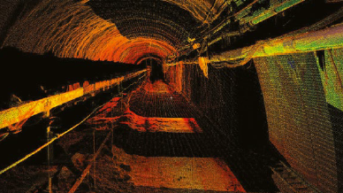
Underground SurveyAlso on the east coast, Brisbane-based Seam Surveys provides mines with both statutory and production mine surveyors on a contract basis throughout the Queensland and New South Wales coal fields. They also undertake mine audits, geodetic surveys for control networks, and mentoring of mine surveyors for registration. Leica products are used exclusively, and the inventory at Seam Surveys includes laser scanners, total stations, digital levels, and GNSS base stations and receivers. All data is processed with Leica’s LGO, Cyclone and 3D Reshaper software.
While servicing all types of mining operations, 70% of Seam Surveys’ work is underground, where they use Leica Viva Total Stations and C10 laser scanners for everything from set out of mine development and conveyors to 3D scans of underground infrastructure, drifts and shafts. Specialising in underground laser scanning, they have used the C10 for developing 3D models to check asbuilt against design, clash-detection with infrastructure, reverse engineering, as well as calculating excavation and shotcrete volumes. Above ground, the C10 was used recently on a Central Queensland site to provide 3D modelling for the expansion of an already complex coal wash plant.
Seam Surveys director Mick Harris said they’ve been busier than ever post the mining boom: “In the past, because the mines could afford it, they had large teams of highly experienced surveyors to manage the expanding operations,” he said. “But those times have changed. Mine survey teams have been scaled down, so there’s a lot of overflow and leave coverage work for us that wasn’t there before.
“Mines could also afford all the latest survey gear,” Mr Harris said. “Today, most surface mines still have long-range laser scanners such as Riegl models for their daily work, but often these aren’t ideal for precise engineering jobs and geotechnical monitoring, so we’re filling that niche too,” Harris said
According to Mr Harris, Seam Surveys has steered towards Leica products because of their high accuracy and reliability, which he says are even more important underground than on the surface.
“Automatic Target Recognition underground with the TS15 Viva Total Station is second to none,” said Mr Harris. “And the gear is tough and dependable, which is essential in the wet, corrosive and dusty mine environment. In our line of work, you just can’t have equipment breaking down when it takes days for a replacement to arrive.” he said.
“Due to explosive methane gas in coal mines, you can’t change batteries underground, so the long battery life of Leica products is very important to us too,” Harris said.
Stability MonitoringSeam Surveys also uses the C10 laser scanner for geotechnical monitoring, where drifts are regularly scanned with sub-centimetre repeatability to detect any movement. Leica’s 3DReshaper software is used for the deviation analysis, volumes and sections of the tunnels.
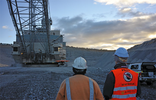
Perth-based company Softrock Solutions uses a Leica MS50 MultiStation for its monitoring work. The company specialises in developing automated robotic surveying systems to detect movement in locations such as pit walls and land slide areas. Softrock’s clients include BHP’s Area C and Jimblebar open pit iron ore mines in the Pilbara. Due to the unique nature of each monitoring project, Softrock develops many of its own software and wireless systems, but for data collection does rely heavily on its Leica MS50 MultiStation, Leica TM30 and TM50 Monitoring Total Stations and TS15 Robotic Total Station. Softrock currently has about 80 monitoring systems installed and operating worldwide, many of which are fully automated and use Leica’s GeoMos software, which can integrate data from geodetic, geotechnical and meteorological sensors.
The company’s general manager Clint Van Der Loon said that, because the depth of many pits increased substantially during the mining boom, the monitoring of slope stability has increased in importance, and there’s some growth in that area of their work, despite reduced production from mines.
Commenting on surveyors reviewing their work practices, Mr Van Der Loon said: “Mines themselves are probably spending less on their survey work now, but are buying higher-end equipment because it means fewer man-hours for data collection and analysis.
“UAV and scanners are relatively expensive, but they provide huge amounts of data and reduce the need for manpower, so there’s some big cost-benefit decisions to be made there,” he said.
Unmanned Aerial Vehicles (UAV)Dubbo-based consulting surveyors Langford & Rowe regularly use a Riegl laser scanner to map mine faces and tunnels, and they use a Leica C10 laser scanner for higher precision work where point cloud acquisition and 3D modelling is required. Their work with the C10 has included surveys for mine process plant and substation renovations.
To survey large areas more efficiently, however, Langford & Rowe approached CR Kennedy for a solution. The solution is a UAVER Avian fixed wing UAV equipped with a Sony NEX7 24 megapixel camera. By September a GLONASS GPS unit should also be onboard, which will allow images to be orthorectified at an accuracy that’s fine for most mine applications. Fewer targets will need to be placed on the ground, and costs will be reduced accordingly.
Domenic Panetta, a director of Langford & Rowe, said they’re finding the UAV hugely beneficial in mining applications. He said a lot of mines have their own UAV for their regular pit work, but call on Langford & Rowe for the less routine work, like stockpile volume surveys and surveys for mine planning.
“For small areas on the mine, using the UAV is much quicker, of a higher quality and more economical than purchasing satellite images,” he said. “And data from the UAV is current, as opposed to satellite images, and that helps greatly with mine planning,” he said.
Looking to work even smarter, Langford & Rowe have been trialling an Aibotix multicopter that CR Kennedy distributes. The multicopter can hover over a point and allow high detail to be captured quickly, so it has plenty of applications. Panetta sees great potential for the multicopter in small pit and stockpile volume surveys, checking stress cracks in a dragline’s workface, and for civil purposes such as inspecting bridges, dam walls and transmission towers.
