


Geoscience Australia and the Intergovernmental Committee on Survey and Mapping (ICSM) have launched the new GDA2020 datum and the gradual journey from GDA1994 to GDA2020 has begun.
The Geocentric Datum of Australia 2020 (GDA2020) is a geocentric (earth-centred) coordinate reference system that is Australia’s new official national datum. GDA2020 will eventually supersede the GDA94 datum. The GDA2020 coordinates differ from GDA94 coordinates by approximately 1.5 to 1.8 metres and are closely aligned with the current GNSS reference framework. The fact that the difference is quite small may make it difficult to work out what reference frame you are on and mistakes will easily be made. It is critical therefore to always be aware what reference frame both your RTK base/mountpoint and rover are using.
To shift existing data from GDA94 to GDA2020 you can apply a transformation to your job on the controller or in the office software.
If you produce data in GDA2020 you must also use the GDA2020 geoid.
Download Working with GDA2020 - Help Files - Here
Do I need to start using GDA2020 now?
Please check what your local state regulations are. Many states have stipulated that from January or February 2019 all new work should be presented in GDA2020. Your client may not know what reference frame the data should be in, but we would recommend switching to GDA2020 from the start of 2019. Ongoing jobs may stay in GDA94 – you can collect the data and easily convert it to GDA2020 later if required using a transformation. Always ask what is wanted and label your data accordingly.
Do I need to use a transformation to get my data from MGA** GDA94 to GDA2020?
No. It is not necessary to transform data between coordinate systems. You can just work on GDA2020 from now on. Do not stick to the old system and convert your data as it adds an extra unnecessary step. If you use your own base station you can obtain GDA2020 coordinates for local site PMs from government state websites for example. All Auspos data is reported in both GDA94 and GDA2020.
https://maps.land.vic.gov.au/lassi/SmesUI.jsp
https://maps.slip.wa.gov.au/landgate/locate/
If you use a CORS network such as SmartNet Aus then choose a GDA2020 mountpoint from the source table. If your correction comes from a known GDA2020 reference, then your rover will then be on GDA2020.
Then what would I need to use the transformation file for?
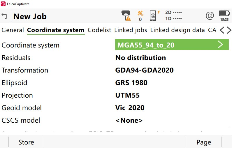
Where you have a job in MGA55 GDA94 AG09 but wish to convert the job to GDA2020 you may use the transformation file to convert the job. This can be done by removing the existing coordinate system and adding a coordinate system with a transformation attached too.
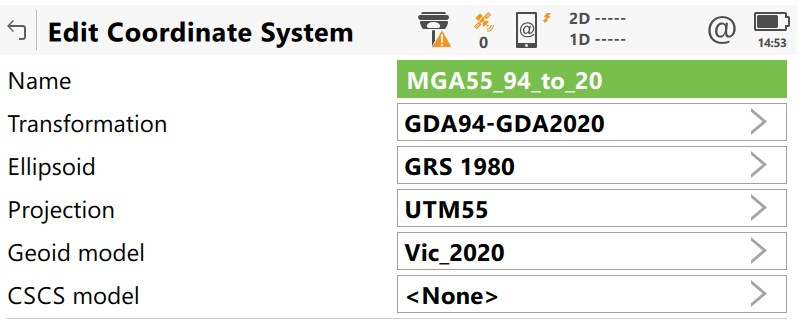
Please use the GDA2020 geoid with the transformation. Contact [email protected] for a copy of the transformation.
How can I get my Captivate SmartNet Aus system to work in GDA2020?
The GPS rover operates on the version of GDA that is selected by the RTK base. When using a network RTK solution of any type you will have the capacity to choose between both GDA94 and GDA2020 reference coordinates by choosing the correct mountpoint.
To change the mountpoint select the Phone icon  and
and 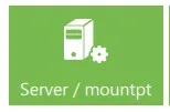 .
.
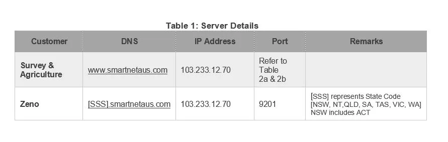
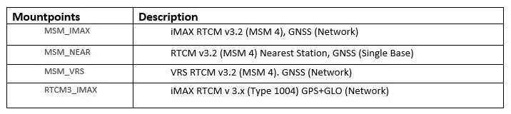
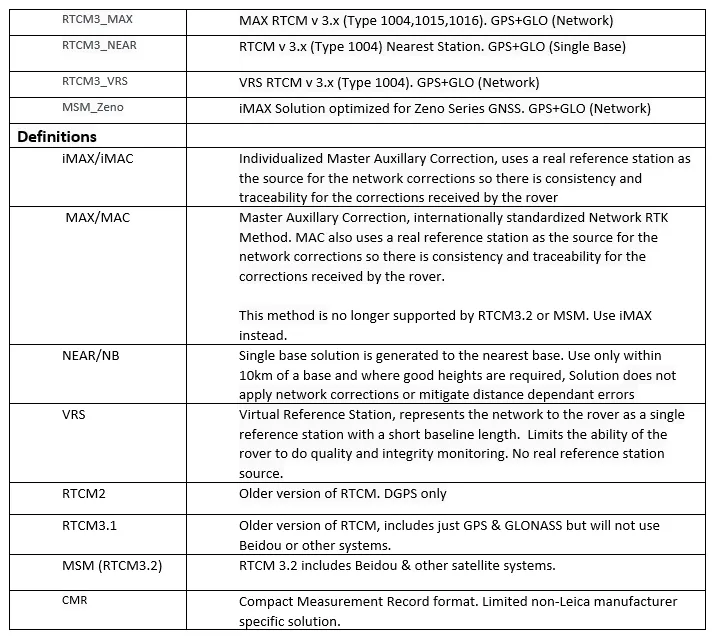
You can select different NTRIP mountpoints by choosing F5 Source. The reference frame is listed as the identifier. See Point 5 for all the mountpoints and access ports. You may wish to create an RTK profile and individual server for each port you may wish to access.
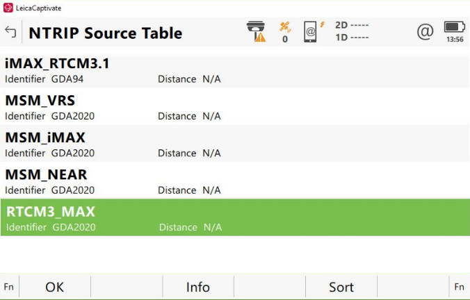
SmartnetAus GDA2020 and RTCM multiple signal messages mountpoints
The tables below show the comprehensive lists of ports and mountpoints available. Please refer to the terms and definitions at the end of this document for more information. There have been no changes to existing GDA94 ports.
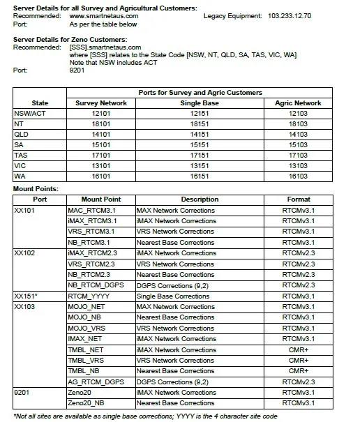
Below are all the new GDA2020 options from Smartnetaus (as of Feb 3rd 2019).
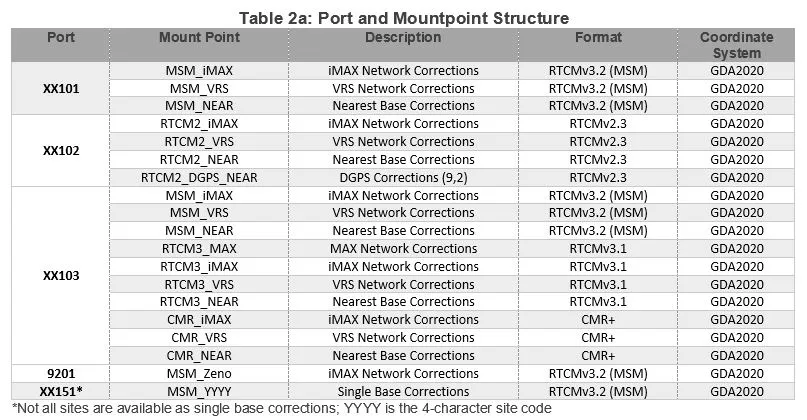
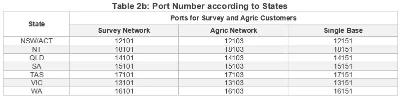
For example In Victoria a customer using GDA94 with a MAC solution who wishes to change to GDA2020 will now choose:
Server: Smartnetaus.com
Port 13101
Mountpoint RTCM3_MAX (identifier GDA2020)
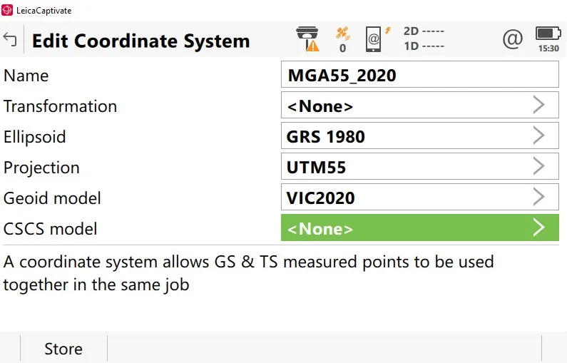
Once you have the correct mountpoint then you can create a job and attach the correct coordinate system. As you have just chosen a new reference frame and are not transforming the data you can just select your usual MGA coordinate system with the new Ausgeoid2020 Gem file for your region.
What if my RTK base/CORS are still on GDA94
You can stay on GDA94, just label your data and check your client’s requirements. If your base is on GDA94 then you can add a transformation to view your data in GDA2020 (and if your base is on GDA2020 you can use the same transformation to view your data in GDA94).
The trick is knowing what your base is on and what you want on your rover. Your GNSS data is always stored in latitude and longitude (GDA94 or GDA2020) so you can add a transformation afterwards to view your data in either.
I am still not sure what GDA2020 is and how it works?
There are some good resources online that will answer all your questions, else contact one of our support team on [email protected]
http://www.icsm.gov.au/datum/gda2020-fact-sheets
Definitions
Where do I get the transformation file and geoid files?
To download the GDA2020 gem files and the TRFSET.DAT containing the transformation file click on the buttons below
Download AU Geoid Files Download AU MGA Files Download AU Transformation Files
If you require a different gem please contact [email protected]
