Have you ever heard of the Leica Pegasus TRK Mobile Mapper? If not, you're in for a treat.
What is the Leica Pegasus TRK Mobile Mapper?
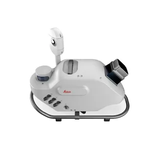
The Leica Pegasus TRK Mobile Mapper is a revolutionary product that has transformed the way professionals collect and process data. With its advanced features and capabilities, this device has quickly become the go-to solution for those who need high-precision and high-resolution mapping in real-time.

But before we dive into what makes the Leica TRK Mobile Mapper so special, let's take a brief step back and explore what mobile mapping is and why it's so important.
Mobile mapping is a technology that uses a combination of sensors and cameras to capture detailed point clouds, images, and data of the environment around us. This data can then be used to create highly accurate maps, models, and other visualizations that are essential in a wide range of industries, from construction and urban planning to transportation and emergency response. If you want to read more about mobile mapping you can go over to this blog for more information.
The Leica TRK Mobile Mapper takes this technology to the next level by offering a comprehensive solution that allows you to map potential area's where you could not previously due to the downfalls of traditional mobile mappers. Ultimately it allows the user to add a variety of new applications to their artillery and speed up traditional methods, which needed more manual hands-on scanning or surveying to complete work scopes more efficiently. Whether you're mapping a busy highway, conducting a survey of a city block, or creating a 3D model of a building, the Leica TRK Mobile Mapper can help you get the job done quickly and accurately.
The Pegasus TRK is built around the concept of a compact and rugged control unit, which is equipped with all the necessary hardware and software to capture, process, and analyse geospatial data in real-time. The system is designed to withstand extreme temperatures, shock, and vibration, making it highly reliable and durable even in challenging conditions.
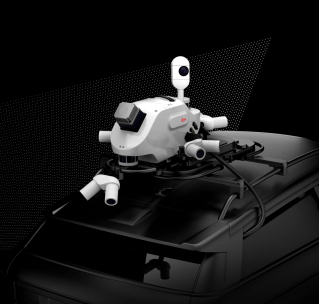
One of the most impressive features of the Leica TRK Mobile Mapper is its ability to capture data in real-time. The RTK (Real-Time Kinematic) mode means that you can see the results of your work as you go, making it easier to adjust and ensure that you're capturing everything you need. Precision RTK positioning gives you location accuracy down to the centimetre in real-time. Additionally, the device is equipped with a range of sensors, allowing the user to capture data from multiple sources simultaneously, including GNSS, IMU, SLAM, and DMI.
The Pegasus TRK is incredibly versatile, with a simple ergonomic mounting system that allows it to be used in a variety of different scenarios. Whether you're mounting it on a vehicle, boat, or a train, the Leica TRK Mobile Mapper is designed to be easy to use and highly adaptable.
But perhaps the most impressive feature of the Leica TRK Mobile Mapper is its integrated software. The device comes with a suite of powerful tools which allow you to process the data you've collected quickly and easily, turning it into highly accurate point clouds, maps, models, and a range of other visualizations.
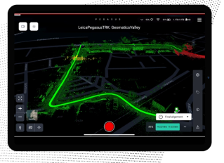
The device's field software, Cyclone Pegasus FIELD, offers features that simplify system initialization and data capture and data pre-processing. With intelligent routing that ensures you're traveling the most efficient route, sensors that trigger autonomously to ensure no details are missed, and real-time notifications that keep you up to date on your progress, Cyclone Pegasus FIELD makes it easy to plan, capture, and deliver your projects quickly and efficiently.
Once you've collected your data, the Leica TRK Mobile Mapper's office software, Leica Cyclone Pegasus Office, offers a range of tools for processing and publishing your results. With support for mobile mapping -relevant information, automatic refinement of data with precision geo-referencing, and multi-pass trajectory adjustment, and point clouds enriched with photo-realistic colours, Leica Cyclone Pegasus Office makes it easy to turn your raw data into highly accurate and visually stunning deliverables.
But the Leica TRK Mobile Mapper isn't just a powerful tool for collecting and processing data – it's also incredibly user-friendly. The device's guided workflows and intuitive tools make it easy for anyone to use, regardless of their level of experience. With suggested profiles that simplify the capture and processing of data, AI-based segmentation that delivers automation, and time savings in asset collection, and high-precision processing that ensures the accuracy of your results, the Leica TRK Mobile Mapper is the ultimate tool for anyone who needs to collect and process data quickly and efficiently.
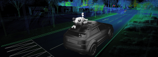
Another impressive feature of the Pegasus TRK is its ability to capture highly accurate 3D data at high speeds. This is made possible by a combination of advanced sensors, including multiple cameras, GNSS antennas, and an inertial measurement unit (IMU). These sensors work together to capture high-resolution images and geospatial data, which are then processed in real-time to produce highly accurate 3D point clouds.
The Leica Pegasus TRK features an onboard AI module, which allows it to automatically detect and classify objects in the captured data. This makes it easy for users to quickly identify and analyse specific features of interest, such as vegetation, signs, buildings, and more. Pegasus TRK is designed to preserve privacy, collected faces and car registration plates are blurred before you return to the office, protecting citizen's privacy and complying with the GDPR legislation. All the imagery data is encrypted assuring your data does not leave your Pegasus TRK unit.
When it comes to data processing, the Leica Pegasus TRK offers a highly intuitive and user-friendly interface that allows users to process captured data quickly and easily. The system is fully compatible with Leica Cyclone, one of the industry's leading software packages for geospatial data processing and analysis.
In addition to its advanced hardware and software features, the Leica Pegasus TRK also offers a range of additional benefits that make it an ideal solution for mobile mapping professionals. For example, the system offers high-speed data transfer capabilities, which allows users to transfer data quickly and easily between the control unit and their office or other devices.
Whether you're a surveyor, a draftsperson, an engineer, or anyone else who needs to capture 3D data accurately and efficiently on the go, the Leica Pegasus TRK mobile mapper is the perfect tool for you. This advanced mobile mapping system is designed to make it easy for professionals to capture high-quality geospatial data while on the move.
So, if you're in need of a high-quality mobile mapping solution that offers accurate, reliable, and efficient data capture and processing capabilities, the Leica Pegasus TRK is an excellent choice. With its advanced hardware and software features, flexible mounting options, and user-friendly interface, it is the perfect tool for capturing high-quality 3D data on the go.