


How IDS GeoRadar’s massive array system empowered a local council to turn underground boulders from annoyance into armour against beach erosion.
Tasked with reconstructing nearly 12,000 sqm of road and replacing nearly a kilometre of water main pipe near Coolangatta’s picturesque Point Danger, City of Gold Coast engineers and crew already knew they had a big job on their hands.
And then they hit a massive boulder under the road surface, bringing the diggers to an abrupt and costly stop.
“So, the council thought we found one, so what can we do to find the rest?” recalls Brad Keane, a Detection Specialist at CR Kennedy who has worked closely with the council.
“Well, the call went out to the materials lab which had the Stream C, and therefore some investigation and scanning capability, to see if there are other potential obstructions in this road.”
The Materials Testing department had indeed recently brought on the massive 3D array GPR system manufactured by IDS GeoRadar known as the Stream C. The team had realised they needed a ground penetrating radar system that is both versatile and accurate.
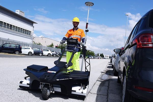
IDS GeoRadar Stream C: ground penetrating radar for real time underground mapping
“We had tried other smaller units and we had to do a grid pattern to try and pick stuff up and get the overall picture,” recalls Alex Munro, Coordinator Materials Testing at City of Gold Coast.
“But with the Stream C we saw that with its massive array it does lend itself to quickly capture some good data over larger areas.”
“We are in an unusual situation in that the section we are in is aligned with both the engineering design arm of our Infrastructure Delivery branch as well as the construction side of it,” he says.
“So, we get involved from investigation through to construction,” he says. “With this equipment, we were looking for it to fulfill a multi-purpose role.”
Usually those purposes have centred on the more common tasks of identifying utility services and looking for voids after slab removal. The Stream C, with its massive array and easy to use software, has been perfectly suited for the wide variety of scenarios the materials testing team find themselves in.
This system allows for dense data collection with 32 antennas spread across a 1m width. This results in an effective scan interval of 4cm between antennas, which allows for detailed images of underground features such as drains and utilities.
But in this instance, they found some very large rocks.
“The guys were able to do a 3D map of the things that reflected the signal under the ground. And they related quite well to the large boulders,” says CR Kennedy’s Brad Keane, who consulted on the project.
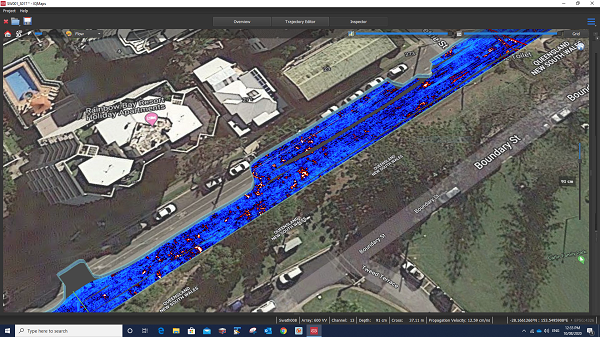
IQ Maps image showing map of signal amplitude at 91cm displaying detected boulders.
But he says a big part of the team’s success with the Stream C GPR system has to do with the new IQMaps software that he says basically processes data on the fly.
“Previously,” Keane says, “you’d have to have an expert stand behind you, and you’d say, hey, can you process the data for us so that we can make the correct interpretation?”
But with IQMaps that processing is now removed, as it uses an algorithm that helps run the data directly.
“It’s more about producing images you interpret rather than radar data that you then have to work on,” Brad says.
“That is what really allowed the Gold Coast team to take ownership of the job and to really roll with it without the need for much geophysics consulting,” he says. “That’s probably what’s really turned the corner for them and allowed them to unshackle.”
With the Stream C and IQMaps, the team was able to produce clear scans that picked up at least 19 discrete boulders.
The largest one, Keane says, was about 34 tonnes and around 10 cubic metres.
“For guys used to working in mines, that might not sound like much but you multiply that out into a 3D space and consider that this was a residential area, it is a very awkward and very difficult project because you can’t just blast them,” Keane says.
Alex Monro of the City of Gold Coast says the scans allowed the team to get strategic when it comes to removing these massive objects.
“There was one especially large boulder that was causing them grief in the trench for the water main relocation, but as it turned out they did end up getting some geotech advice on that obstacle and ended up being successful using a rock breaker to reduce the size,” he says. “So they just were able to remove that one in fragments.”
And now that the team has a complete map showing the location and size of these massive inconveniences, the team has been able to go through with an excavator and pluck out whole boulders and put them to the side.
Alex Munro says city engineers are keen to hang onto them as they think they have found a way to put them to very good use.
“I understand they are retaining them for potential reuse as rock protection for storm events on our seawalls,” he says.
The City of Gold Coast, like other coastal areas just about anywhere in the world, has seen massive impacts from coastal erosion due to rising seas and swells. Massive boulders like these can help armour the beaches and stem the erosion.
So while they were a giant inconvenience for the road crew, they will now be a valuable resource in the fight to protect one of the council’s most valuable resources – its beaches.
Read the full article at: Spatial Source

