

Pix4Dfields

- Advanced agriculture mapping software for aerial crop analysis and digital farming.
- Create precision agriculture maps using images from drones and satellite.
- The only hybrid mapping software solution for agriculture based on knowledge from farmers, agronomists, and researchers.
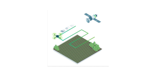
Remote Sensing
Collect images using a drone and any standard RGB or select multispectral cameras.
You can also use Satellite Data Import to enhance your mapping experience with Sentinel-2 satellite data.

Process
Process imagery with the instant processing engine and get your maps directly in the field: 6.8 GB, 2948 images, 10 min (with the new radiometry module).
Scout
Generate precise orthomosaics, digital surface models, index maps, zones and accurate prescription maps.
Trim your fields to a desired field boundary to create more targeted outputs.


Analyse
Visualize and understand your crop growth stages and stress levels.
Analyse and compare different layers of information for a full insight of your yield performance and use them to increase crop production and reduce costs.
Share
Share your maps with all project stakeholders for seamless collaboration using PIX4Dfields' PDF report tool or using the share to PIX4Dcloud feature.


Integrate
Download all outputs, results and insights and import them into the Farming Management Software of your choice in various industry standard formats.


Brand: Pix4D |
Code: PIX4DFIELDSPERP
Supplier Code: PIX4DFIELDSPERP
Brand: Pix4D |
Code: PIX4DFIELDSPERP
Supplier Code: PIX4DFIELDSPERP
At a glance
- Advanced agriculture mapping software for aerial crop analysis and digital farming.
- Create precision agriculture maps using images from drones and satellite.
- The only hybrid mapping software solution for agriculture based on knowledge from farmers, agronomists, and researchers.
