

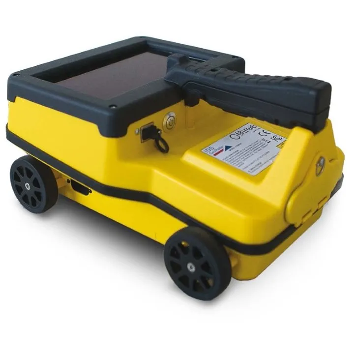
IDS Georadar C-THRUE all-in-one Ground Penetrating Radar (GPR)

See thru concrete structures and reveal true data that lead to optimal decision-making
C-thrue is an all-in-one Ground Penetrating Radar (GPR) for accurate scanning and real time analysis of concrete structures. Construction and service companies as well as civil and structural engineers can now improve the way they locate rebars, voids, post-tension cables, cavities, conduits, and any other objects buried in the structure before cutting or drilling into the concrete.
C-thrue is an easy-to-use and robust solution to see through concrete structures and reveal true data that lead to optimal decision-making. The solution is suited for all construction sites and operations including building renovation, overpasses, monuments, bridges and tunnels surveys, as well as for detailed analysis of the original engineering project and comparison with the as-built structure.
Today, C-thrue offers more flexibility with no limitations for your analysis requirements, thanks to a compact and light telescopic pole and an external controller that can be easily transported on site in challenging locations or conditions (e.g. under a deck, along vertical walls, etc...).
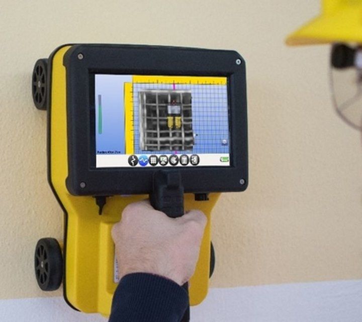
The C-thrue external controller allows easier and faster data interpretation thanks to real-time data processing and representation of results in Augmented Reality for more efficient decision-making.
C-thrue - Advanced GPR software to process data in the field
The C-thrue software makes possible what was a dream until now! With just the press of a button, the system automatically recognises and discriminates rebars and voids in concrete structures.
The software is specifically developed and suitable for in the field analysis:
- Automatic system calibration for an easy and quick set-up and start
- Automatic recognition of rebars and voids in concrete structures
- Digital on-site representation of data and targets through Augmented Reality
- Real time visualisation of 3D radar tomography
- Real time data sharing enabling double data visualisation and high resolution imaging both on product display and remote desktop connection to external device
- Capability to mark targets within the software
- Fully integrated with GRED HD post-processing software
- Ability to export full survey report
GRED HD 3D - Advanced GPR processing and imaging software
GRED HD 3D is an advanced post-processing software enabling users with the following functionalities:
- Radar-scan viewer, filter and advanced filtering macros
- Layer picking for automatic analysis of sub-layers
- Tomographic map view (C-Scan) including radar scan fusion
- 3D data visualisation
- Advanced targeting using radar-scan and tomographic view
| Case Studies | |
|---|---|
| C-thrue DD Rev3 - Case Study | |
| IDS C-Thrue Case Study - Slab With Plumbing Services - Case Study | Brochures |
| LG868510 - Brochure | Datasheets |
| IDS Georadar C-THRUE all-in-one Ground Penetrating Radar (GPR) - Datasheet |
Brand: Leica Geosystems |
Code: LG868510
APN: 9319499079703 |
Supplier Code: 868510

Brand: Leica Geosystems |
Code: LG868510
APN: 9319499079703 |
Supplier Code: 868510
At a glance
See thru concrete structures and reveal true data that lead to optimal decision-making
