

DJI GS Pro Enterprise V1 Software
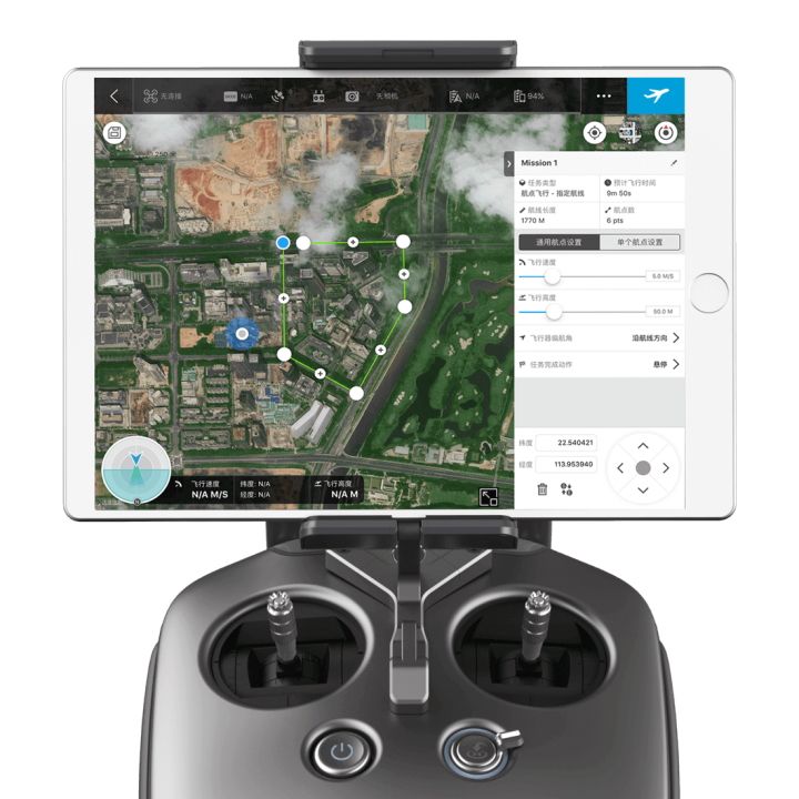
Enhance your drone operations with the DJI Ground Station Pro (DJI GS Pro) iPad app. Conduct automated flight missions, manage flight data on the cloud, and collaborate across projects to efficiently run your drone program.
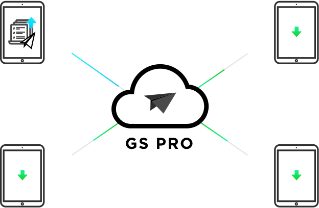
FLIGHT DATA MANAGEMENT
Back up flight data securely on the cloud, giving missions higher reliability and accuracy.
Reference historical information on flight missions, aircrafts, members, and flight logs so that workflows can be optimized.
Flight mission data is visible to all members of a project team, making data sharing easier.
Members can view edits made by other team members, or duplicate flight parameter settings for new missions.
FLEET AND PILOT MANAGEMENT
Manage pilots and drones through the creation of teams, making missions more coordinated.
Designate roles with different permissions to improve communication.
Track the status of aircrafts to make proactive purchasing and maintenance decisions.
|
Agent
|
Administrator
|
Member
| |
|---|---|---|---|
|
View all projects
|
✓ | ✓ |
Only projects they are in
|
|
View all flight logs
|
✓ | ✓ |
Only flight logs they created
|
|
View all members
|
✓ | ✓ |
-
|
|
Add/delete members
|
✓ | ✓ |
-
|
|
Modify member permissions
|
✓ |
-
|
-
|
|
Purchase and renew software license
|
✓ |
-
|
-
|
PROJECT MANAGEMENT
Improve the efficiency of your drone operations by tracking individual projects and streamlining the project management process. Access to project status can be granted on a per project basis so that critical data is only available to the relevant members.
|
Project Manager
|
Operator
| |
|---|---|---|
|
Manage personal flight missions
|
✓ | ✓ |
|
View flight missions of other members
|
✓ | ✓ |
|
Copy mission settings of other members
|
✓ | ✓ |
|
Archive and unarchive projects
|
✓ |
-
|
|
Manage project members
|
✓ |
-
|
|
View historical mission activities
|
✓ |
-
|
|
Set flight parameters from a particular mission as default settings
|
✓ |
-
|
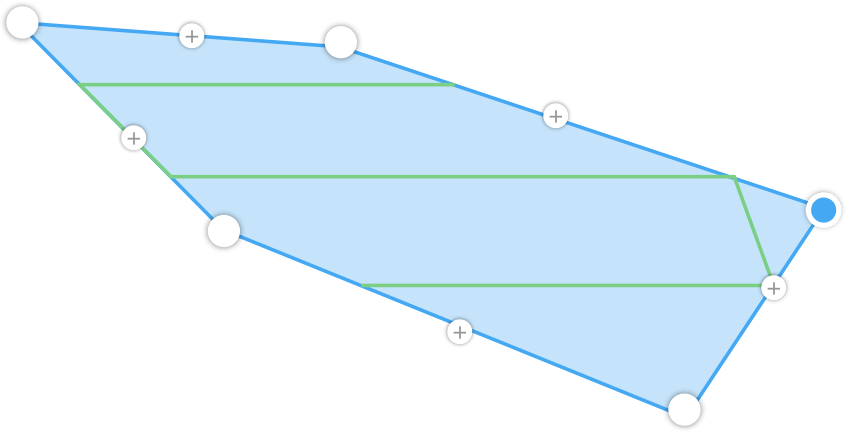
3D MAP AREA
GS Pro automatically generaet efficient flight paths after the user has set their required flight zone and camera paramters.
The aircraft will then follow this route throughout its mission. The image data captured during these flights can be input into 3D reconstruction software to generate 3D maps, while the mission itself can be save for re-use.
3D MAP POI (In app purchase)
Generate detailed maps of tall structures using 3D Map POI. Simply choose the subject and set a distance between it and the aircraft. DJI GS Pro will then provide relevant parameters including speed and time required to circuit the structure. Images captured can be exported into 3D reconstruction software to create accurate 3D models of the entire building.
TAP AND GO WAYPOINT FLIGHT
After the aircraft finishes its flight mission, it can be set to Return to Home, Hover, or Land.
Set a waypoint flight path, define waypoint actions, then start flying with a tap.
VIRTUAL FENCE
Virtual fence defines a specific area of flight and is useful in scenarios where some areas of a
site are no-fly zones or if flight should only happen within one area, such as during manual
pesticide spraying or flight. It is also useful in pilot training situations. As the aircraftapproaches the virtual fence, it will brake and hover to ensure it stays within the flight area.

The size and shape of the Virtual Fence is completely customizable.It can be created pre-flight, or fly around the zone to mark boundariesusing the aircraft’s GPS coordinates.
INDUSTRIAL APPLICATIONS
DJI GS Pro is a powerful, convenient and easy to use tool. With just a few taps on an iPad, complex flight routes can be created,
giving critical missions added accuracy and reliability. DJI GS Pro is an indispensable tool that is capable of dramatically increasing efficiency in a wide range of industries, includding:
Architecture,
Precision agriculture,
Electrical inspections,
Aerial imaging,
Safety control,
Search & rescue,
Surveying,
Mining.
COMPATIBLE PRODUCTS
DJI GS Pro is compatible with the following DJI aerial platforms and flight controllers:
Mavic 2 Enterprise, Mavic 2 Pro, Mavic 2Zoom, Mavic Pro, Phantom 3 Standard/Advanced/Professional/4K,
Phantom4, Phantom4 Pro, Phantom 4 Pro V2/Advanced, Phantom 4 RTK,
Matrice 200 V2, Matrice 210 V2, Matrice 210 RTK V2, Matrice 210, Matrice 210 RTK, Matrice 100,Matrice 600/Pro, Matrice 200,
Inspire 1/Inspire 2, A3, N3
COMPATIBLE CAMERAS
Mavic 2 Enterprise, Mavic 2 Pro, Mavic 2 Zoom, Mavic Pro, Phantom 3 Standard/4K/Advanced/Professional,
Phantom 4/Pro, and Zenmuse X3, X5, X5R, X4S,X5S, Z3, Z30, XT, XT2 and Mavic 2 Enterprise Dual.

"Best prices guaranteed! We’ll match or beat any legitimate prices."
Read the CASA Drone regulations @ knowyourdrone.gov.au
Brand: DJI |
Code: DJIGSPROENTV1
Supplier Code: DJIGSPROENTV1

Brand: DJI |
Code: DJIGSPROENTV1
Supplier Code: DJIGSPROENTV1
At a glance
Enhance your drone operations with the DJI Ground Station Pro (DJI GS Pro) iPad app. Conduct automated flight missions, manage flight data on the cloud, and collaborate across projects to efficiently run your drone program.
"Best prices guaranteed! We’ll match or beat any legitimate prices."
Read the CASA Drone regulations @ knowyourdrone.gov.au
|
Agent
|
Administrator
|
Member
| |
|---|---|---|---|
|
View all projects
|
✓ | ✓ |
Only projects they are in
|
|
View all flight logs
|
✓ | ✓ |
Only flight logs they created
|
|
View all members
|
✓ | ✓ |
-
|
|
Add/delete members
|
✓ | ✓ |
-
|
|
Modify member permissions
|
✓ |
-
|
-
|
|
Purchase and renew software license
|
✓ |
-
|
-
|
PROJECT MANAGEMENT
Improve the efficiency of your drone operations by tracking individual projects and streamlining the project management process. Access to project status can be granted on a per project basis so that critical data is only available to the relevant members.
|
Project Manager
|
Operator
| |
|---|---|---|
|
Manage personal flight missions
|
✓ | ✓ |
|
View flight missions of other members
|
✓ | ✓ |
|
Copy mission settings of other members
|
✓ | ✓ |
|
Archive and unarchive projects
|
✓ |
-
|
|
Manage project members
|
✓ |
-
|
|
View historical mission activities
|
✓ |
-
|
|
Set flight parameters from a particular mission as default settings
|
✓ |
-
|
3D MAP AREA
GS Pro automatically generaet efficient flight paths after the user has set their required flight zone and camera paramters.
The aircraft will then follow this route throughout its mission. The image data captured during these flights can be input into 3D reconstruction software to generate 3D maps, while the mission itself can be save for re-use.
3D MAP POI (In app purchase)
Generate detailed maps of tall structures using 3D Map POI. Simply choose the subject and set a distance between it and the aircraft. DJI GS Pro will then provide relevant parameters including speed and time required to circuit the structure. Images captured can be exported into 3D reconstruction software to create accurate 3D models of the entire building.
TAP AND GO WAYPOINT FLIGHT
After the aircraft finishes its flight mission, it can be set to Return to Home, Hover, or Land.
Set a waypoint flight path, define waypoint actions, then start flying with a tap.
VIRTUAL FENCE
Virtual fence defines a specific area of flight and is useful in scenarios where some areas of a
site are no-fly zones or if flight should only happen within one area, such as during manual
pesticide spraying or flight. It is also useful in pilot training situations. As the aircraftapproaches the virtual fence, it will brake and hover to ensure it stays within the flight area.
The size and shape of the Virtual Fence is completely customizable.It can be created pre-flight, or fly around the zone to mark boundariesusing the aircraft’s GPS coordinates.
INDUSTRIAL APPLICATIONS
DJI GS Pro is a powerful, convenient and easy to use tool. With just a few taps on an iPad, complex flight routes can be created,
giving critical missions added accuracy and reliability. DJI GS Pro is an indispensable tool that is capable of dramatically increasing efficiency in a wide range of industries, includding:
Architecture,
Precision agriculture,
Electrical inspections,
Aerial imaging,
Safety control,
Search & rescue,
Surveying,
Mining.
