Cheaper, Safer, Faster

50L Spray
Tank
(T40 Model)

Active Phased Array Radar + Binocular Vision

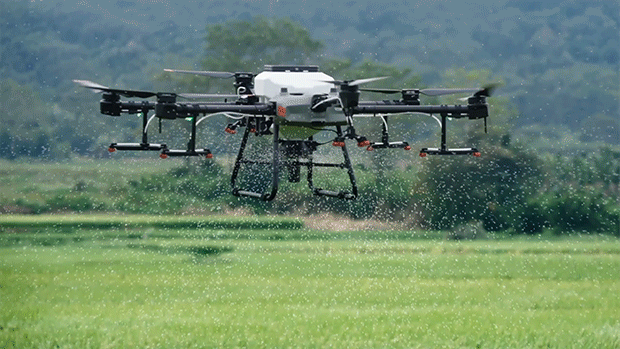
Dual Atomized Spraying System

Supports flight spraying/spreading and RC mapping

Core Modules

The AGRAS T40 combines mapping, spraying and spreading functions, while its UHD camera and adjustable gimbal enable easy capture of your desired view. Farmland and orchard images can be captured in real time, and local maps can be generated using the remote controller with the D-RTK 2 Mobile Station. The system detects land boundaries and obstacles automatically, for quicker planning of flight routes over farmland and hilly orchards

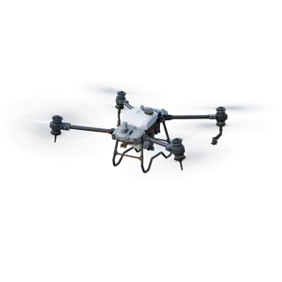
The Agras T30 crop spraying drone has the largest spray tank of all of the Agras drones, with as 30L operation tank. It also benefits from a 30kg spreading tank. This huge capacity increases operational efficiency.
The Agras T30 benefits from the latest advances in drone technology, including IP67 rated waterproofing and fully self-directed, high precision work through RTK positioning and the Zhihui agricultural cloud platform.
Monitor autonomous and manual flights with dual front and back FPV cameras, along with a spherical radar sensing system to maximise safety during complex operations.

The T10 builds upon DJI’s existing Agras farming drone platform, with powerful spraying and spreading capabilities.
The Agras T10 boasts a 10L spraying tank and 10kg spreading tank. It is also IP67-rated for a reliable performance in inclement weather and benefits from a RTK module for centimetre-level positioning.
Monitor autonomous and manual flights with dual front and back FPV cameras, along with a spherical radar sensing system to maximise safety during operations.
This updated spreading system has a capacity of up to 40L a spreading width of up to 7 meters, [6] and an hourly spreading capacity of 1 ton. This system also supports real-time weight monitoring and has an anti-rotation sensor, allowing more accurate refill alerts. The T30’s overall water-resistance rating of IP67 rating makes it washable and corrosion-resistant ideal for spraying of fertilizers, seeds, and feed. When used with digital agriculture solutions, the Agras T30 implements variable spreading, reducing fertilizer use while increasing yield.
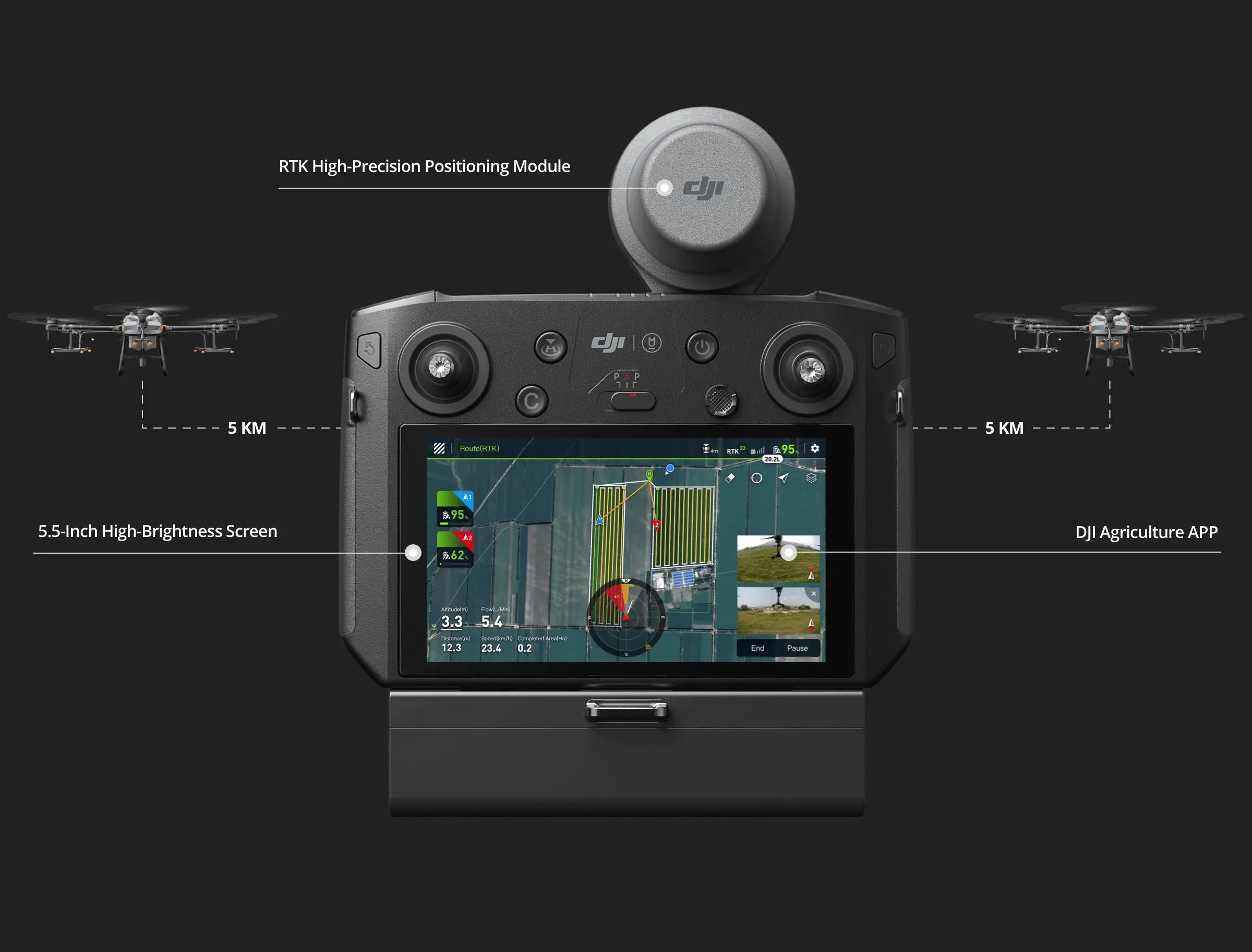
An updated remote controller supports stable image transmission from up to 5 km away, 67% more than the previous generation. [3] A bright 5.5-inch screen delivers clear visuals , even in harsh lighting conditions. For increased productivity, one remote controller can operate multiple drones at once. The standard RTK high-precision positioning module implements centimeter-level operation planning. Additional enhancements include stronger signaling, anti-interference, and operational stability. The new DJI Agriculture app provides a smooth user experience and more intuitive operation.
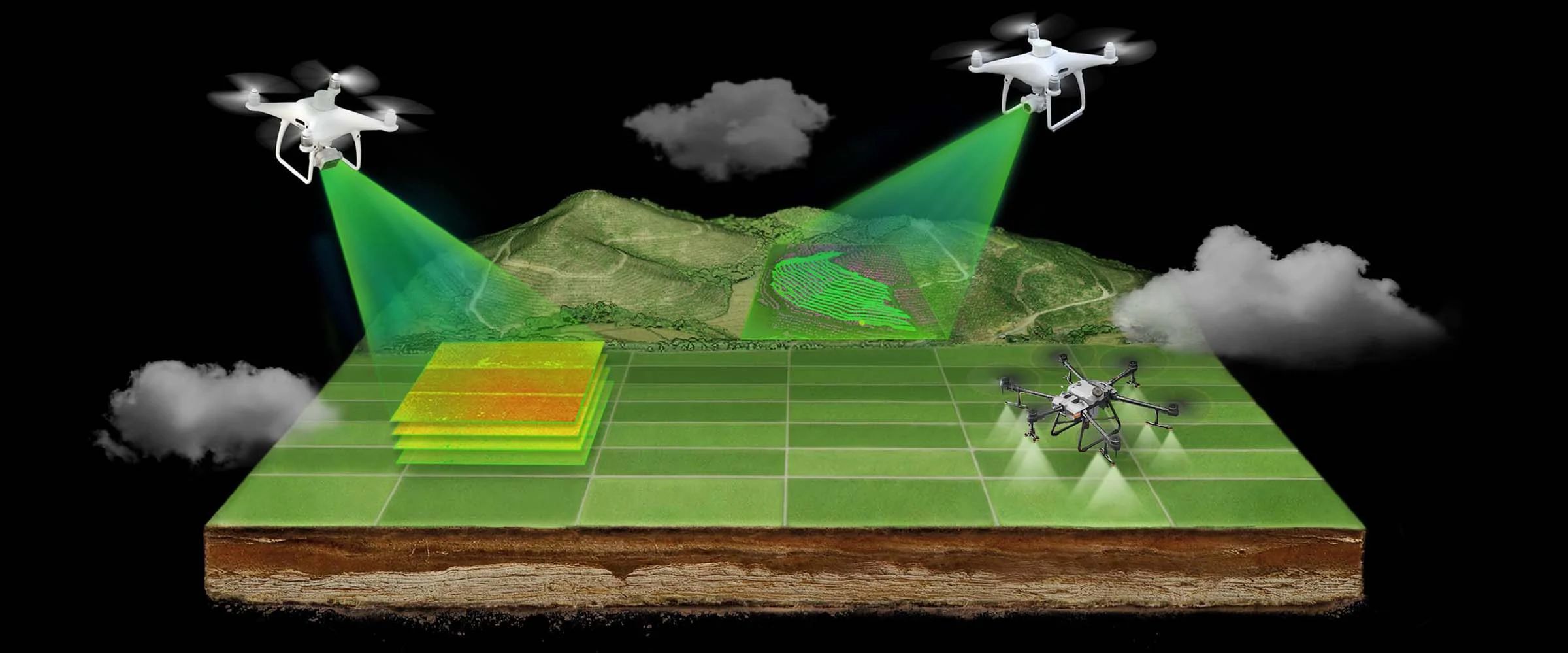
With the Smart Agriculture Cloud Platform, users can perform cloud-based mapping of orchard and farmland scenarios to generate smart flightpaths. This platform is equipped with an AI recognition system to patrol fields, identify growth, monitor disease or pests, and monitor agricultural conditions efficiently. Pairing this system with the DJI P4 Multispectral allows users to apply solutions based on specific variables according to an automatically-generated farmland prescription map.
| Company | Website | Address | Phone | |
|---|---|---|---|---|
| C.R.Kennedy VIC | survey.crkennedy.com.au | 300 Lorimer St Port Melbourne, VIC | sales@crkennedy.com.au | 03 9823 1533 |
| C.R.Kennedy NSW | survey.crkennedy.com.au | Level 2, 15 Bourke Road Mascot, NSW | sales@crkennedy.com.au | 02 9552 8300 |
| C.R.Kennedy QLD | survey.crkennedy.com.au | Level 3, 203 Wharf Street Spring Hill, QLD | sales@crkennedy.com.au | 07 3632 6777 |
| C.R.Kennedy SA | survey.crkennedy.com.au | 77 Fullarton Road Kent Town, SA | sales@crkennedy.com.au | 08 8410 0533 |
| C.R.Kennedy WA | survey.crkennedy.com.au | Unit 1, 5 Gibberd Road Balcatta, WA | sales@crkennedy.com.au | 08 9489 8500 |
| AGDRONE | agdrone.au | 4590 BRACKENDALE ROAD NOWENDOC, NSW | info@agdrone.au | 0428 468 483 |
| DJ AERIAL PROMOTION | djap.com.au | PO Box 29 Avenel, VIC | dan@djap.com.au | 0423 422 947 |
| Drone Land | droneland.au | 32 GLENBARRY ROAD CAMPBELLFIELD, VIC | info@droneland.au | 0484 191 198 |
| Drone Shop Perth | droneshopperth.com.au | 6 WALKINGTON WAY EDEN HILL, WA | sales@droneshopperth.com.au | 08 6278 1333 |
| DRONE TECH SOLUTIONS | dronetechsolutions.com.au | 1 ANZAC AVENUE MARIAN, QLD | admin@dronetechsolutions.com.au | 0428 781 059 |
| FIELD MASTER SYSTEM | fieldmastersystems.com | 77 GRANITE DRIVE LANGWARRIN, VIC | john@fieldmastersystems.com | 0429 353 205 |
| FULCRUM ROBOTICS PTY LTD | fulcrumrobotics.com.au | 5D/52 ASCOT DRIVE HUNTINGFIELD, TAS | michael@fulcrumcs.com.au | 0417 218 646 |
| NQ COMMERCIAL DRONE | nqdrones.com.au | 36 Abbott Street, Cairns, QLD | admin@NQDrones.com.au | 0431 112 299 |
| Ramsey Bros | ramseybros.com.au | 21 Fuschia Road, Murray Bridge, SA | Sales@ramseybros.com.au | 08 8628 2100 |
| RIPPER CORPORATION | rippercorp.com | PO Box 5, Broadway, NSW | info@rippercorp.com | 1300 46747737 |
| Skynet drone services | skynetdroneservices.com.au | 22 Gardner St Koo Wee Rup, VIC | info@skynetdroneservices.com.au | 0417 553 324 |
| SKYTECH SOLUTIONS PTY LTD | skytechsolutions.com.au | 4 KILLARA COURT GOONELLABAH, NSW | enquiries@skytechsolutions.com.au | 0458 486 856 |
| TRAVEARTH DRONE SERVICES | travearth.com.au | 107 WELLINGTON ST AITKENVALE, QLD | trav@travearth.com.au | 0423 638 628 |
| UNCREWED OPERATIONS P/L | uncrewed.au | 7/1 BRONBERG COURT SOUTHPORT, QLD | info@uncrewed.au | 0412 917 220 |
| WIDE BAY DRONES | widebaydrones.com.au | 53 JAMES HENDERSON WAY GOOBURRUM, QLD | info@widebaydrones.com.au | 0474 541 343 |

C.R. Kennedy is your national partner for all positioning needs from surveying to machine control, building construction to reality capture and everything in-between. Wherever you are in Australia, C.R. Kennedy are with you, providing an unparalleled level of service and support from industry experts to get the job done safely and efficiently.
Shop Safely and Securely with
@ C.R.Kennedy Geospatial Solutions
Our Brands
© 2024 C.R. KENNEDY. All rights reserved.
ICON SITE EXCAVATOR
SPECIAL OFFER - LIMITED TIME
A simple machine control solution ideal for compact excavators — with a big payoff!