

Infinity UAV image processing: Accurate and Reliable Results
By Anargyros Martyridis Application Engineer, Leica Infinity
The revolution of the unmanned aerial vehicles (UAVs) has opened doors to the use of new data capturing methods in various fields. However, it is important to build trust in the accuracy and reliability when using these new tools and their data deliverables. Assessing data quality is always an important requirement for users.
There have been a lot of studies with the main goal of assessing the quality of UAV deliverables and answering basic questions such as, “How good is the orientation?”, “How accurate is the dense point cloud?” or even “Can this data be trusted?”
We know the importance of giving the correct answers to such questions, that’s why we provide the tools users need to assess the quality of the data deliverables and being able to rely on them.
Removing the complexity
The democratisation of point clouds and the ability to integrate UAV technology encourages users at all levels to utilise UAV image processing in their day to day work. Keeping in mind however, that the image processing topic is rather complex considering the algorithms required to process and derive data outputs. We keep the easy-to-use approach for processing and quality assessment, providing a set of tools and reports that help users build their trust in the UAV image processing data deliverables . A step further, Infinity.
How to trust your UAV data
The basic requirement for a user is to be sure the results of UAV image processing meet the project needs in terms of accuracy and completeness. To be sure that the data can be trusted, it is important to include the following steps:
Ground Control Points for providing data reliability:
Using geotagged images, the orientation is always computed with respect to a coordinate system. If a high-degree of absolute accuracy is required, Ground Control Points (GCPs) must be acquired. They can also assist in reducing uncertainty due to camera calibration or help orientate images in difficult situations.
Check Points for understanding data accuracy
To assess the accuracy of the image orientation, Check Points (CPs) are needed. CPs are measured points not used as a ground constraint. They are easily marked on images but used as an independent check to the orientationquality.
The orientation report is the place where you can find all the information related to GCPs and CPs and allows the user to both check residuals on GCPs and assess the accuracy of the image orientation.
To assess the accuracy of the processing results, differences between the computed and the actual position of each CPs is reported, along with some statistics. If these differences are within the tolerances a user has defined, the result of the orientation can be considered accurate.
The American Society of Photogrammetry and Remote Sensing (ASPRS), sets standards for digital data positional accuracy which the Leica Infinity team has used as guidelines in building the reporting to show and evaluate the accuracy of the results.
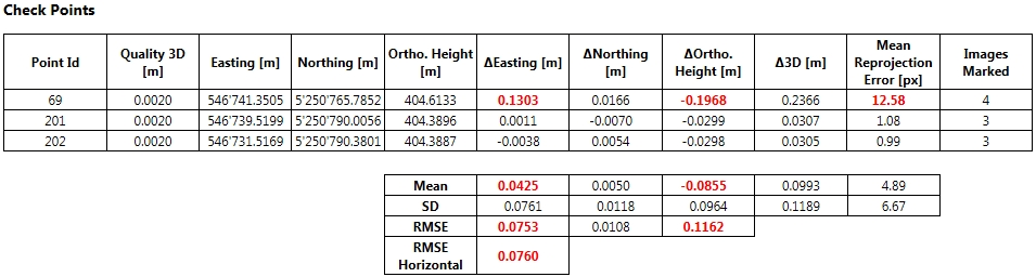
Figure 1: Check Points example from the image orientation report. It is easy to notice the values that do not meet the set tolerances.
Enhanced dense point cloud: all the information you need
Once the user has assessed the first step, it’s an easy process to generate the Dense Point Cloud (DPC). The tools for easy analysis and user awareness for trusting the quality of the point cloud are also available.
Infinity provides a DPC that is enhanced since each of the points also carry an absolute quality information. This provides users with the ability to define a value for the accuracy that is used for the point cloud output result.
Based on a simple filtering threshold that corresponds to the absolute accuracy value, you can set the values according to the specific needs. A user can easily tighten or relax the accuracy of the point cloud filter, to get either a more accurate or a more complete DPC. This can be done within a few seconds and without having to reprocess from the images. This means users can try various filtering thresholds and keep the one that fulfills the requirements for their project. This is a great benefit as it saves a lot of time.
Completing the trust: fully integrated
One more important factor to consider is that Infinity integrates the UAV image processing with all existing survey measure tools. To have complete trust in one’s data, it is easy to combine either Total Station observations or GNSS measured points even for GCP’s and CPs. This combining of sensors with UAV processing is another way for users to know their data is accurate and reliable. This results in users being able to take advantage of working with complimentary sensors and design data all in one software.
Summary
To build trust for UAV data, you need easy-to-use and reliable tools for assessing the quality of the orientation and the dense point cloud. Leica Geosystems provides all the means to help evaluate the quality of the end results and build the trust that these comply with the project requirements and users can rely on them.
Read more about Leica Infinity surveying software here
Leica Aibot UAV solution has an integrated workflow with Infinity, you can find more information here
